Douglas Partners has recently endorsed the content of the AusCalVal report, ‘Establishing Australia as a Global Leader in Delivering Quality Assured Satellite Earth Observation Data’.
DP’s consulting work is becoming increasingly more reliant on satellite information. Our consultants use Douglas Map, a highly advanced version of Google Earth, to achieve high resolution aerial photos taken from aeroplanes.
We depend on the GPS constellation of satellites to accurately locate our boreholes and other site features. LiDAR ground elevation models are used in our earthworks calculations and offer a useful check of GPS elevation measurements. In addition, we have begun to consider how Synthetic Aperture Radar, and Hyperspectral data might bring value to our consulting operations.
The Aus Cal/Val report outlines Australia’s requirements for quality assurance of satellite Earth observation data and the infrastructure needed to ensure the operational success and achievability of reliable, enduring, and high-quality satellite Earth observations. It highlights the key opportunities that, if taken up, could support Australia in becoming a global leader in testing and quality assurance for domestic and foreign satellite Earth observation missions, accelerate the growth of the Australian space sector, and create opportunity and resilience for the nation.
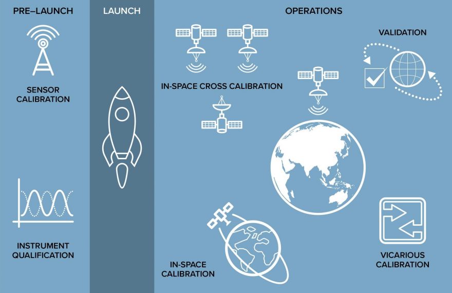
Quality assurance for Earth Observation Satellites (Source: Frontier SI Aus Cal/Val Report)
Image at the top of the page: Sentinel-2A image from 25/03/2021. True colour view of sediment emerging from the Hawkesbury River during the NSW Floods. Produced from remote sensing data by the European Commission, processed by Digital Earth Australia, Geoscience Australia.